Welcome to nectaexams.com, your premier destination for comprehensive educational resources in Tanzania. In this section, we delve into FORM FIVE GEOGRAPHY: Theory of Continental Drift. Our notes are meticulously crafted to provide both students and teachers with a deep understanding of the pioneering theory that explains the movement of continents over geological time. Whether you are preparing for exams, enhancing your classroom learning, or seeking to broaden your geographical knowledge, our notes offer valuable insights and structured information to support your educational journey. Explore this topic with us and uncover the historical development, key evidence, and significant impacts of the Theory of Continental Drift in the field of physical geography.
THEORY OF CONTINENTAL DRIFT (sib-topic of physical geography)
There are 7 continents
Origin of these continents
Propounders
– Francis Bacon (1620) Expanded earth
– F .B Taylor
– Alfred Wegener 1912.
According to his theory ,about 280 million years,the present day continents were united in a single block called Pangaea and sorrounded by ocean called Panthalassa.He believed that Pangaea was located near the South pole.Later Pangaea split into two (2)Super-continental
i.e Gondwanaland(south Pole) and Laurasia(along the equator in the northern hemisphere).
These two Super-Continents were separated by a narrow water body i.e Tethys sea.He assert that Laurasia split to form present day N.America,Asia,Europe,and numerous landmasses found in northern Hemisphere-Greenland,Iceland and United Kingdom.
Gondwanaland split to give present day Africa,S.America,Australia and Indian sub-continent,Antarctica and other islands in the southern Hemisphere.
Drift:
Since that time the continents have been drifting apart to occupy their present positions. And the drifting is a very slow one about 2cm per year. The drifting is still in progress.
Evidence to support Wegeners theory of Continental Drift
1. Structural evidence ( Jig saw fit)
If the continents were to be brought together it will form one single landmass called Pangaea. Hence proves that all the continents come from one land mass. For example S. America could fit into Africa, N. America into Europe, Antarctica, Australia, India and Malagarasy formed in a single landmass with S. America.
2. Geological evidence :
Similar rock types in the coastal margin of the continents for example if you take the rocks of west Africa coastal margin and those of Eastern coast Brazil coastal margin the rocks will be the same (similar ) These rocks where one before the split. (Similar type, age, structure, formation)
3. Biological evidence :
The study of earlier life in sedimentary rocks. That reveals life similar fossils of different time where found in different places. Similar animals, plants and e.g. .These fossils are found in all continents hence prove that they all come from one landmass
4. Geomorphologic evidence:
Structure of mountains ( fold mountains) e.g. The Alps and Atlas have similar features and where also formed under similar conditions, type of rocks the mountain case, structure, alignment and were formed when Africa moved north wards ending up colliding with the European continent. This gives evidence that the drifting movement took place.
5. Pale-climatic evidence:
The discovery of ancient is in the Congo basin where the climate is warm is used as evidence that the Africa continent drifted from parts which were cold to the current warm parts. For example, Africa has been shifting north wards from the south likewise coal deposit found beneath Antarctic ice caps and Greenland show that they were deposit when the continents had not drifted led to those places when the climate coast warm. This is because the organisms that led to the formation of those deposits cannot east in areas where there is very low temp.
6. Paleo magnetism (palae-magnetic evidence).
This is the most conclusive proof of the continental drift which was done through pale magnetic dating. When the rocks cooled they were magnetized in the same direction (magnetic North) but pale magnetic dating shows that rocks older than 200,000 years ago from different parts of the earth, have shifted their relative positions magnetic fields show new paths representing relative migration of the earth’s materials
This is evidence that the continents have drifted or have been drifting.
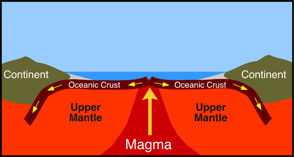
7. Ocean floor spreading.

Weakness of Wegener / critiques of the theory
1) He did not explain how the movement has occurred / the continental drift processes.
2) He was not a geologist but meteorologist hence he was criticized to have involved in the field where he was probably less informed.
3) Not all continents are able to fit exactly as argued in the jig-saw fit theory, but the theory does not account for this aspect.
4) Other scientists argue that the plant remains might have been spread by aspects like wind, blowing from one continent to another.
5) Wegner failed to explain the development of glacier in the hot arid Australia.
We hope these notes on FORM FIVE GEOGRAPHY: Theory of Continental Drift have provided you with a thorough understanding and appreciation of the dynamic nature of the Earth’s surface and the scientific advancements that have shaped our comprehension of continental movements. At nectaexams.com, we are committed to supporting both students and teachers by offering high-quality, detailed educational content for Form Five and other levels of education. Continue to use our platform for all your study and teaching needs, as we strive to be your trusted partner in academic success. Remember, a well-rounded education is the key to unlocking your future, and nectaexams.com is here to help you every step of the way. To download these notes in PDF, please visit this link from nectanotesPDF.com.


